In today’s fast-paced world of land development, the demand for precision, speed, and reliability has never been greater. Traditional surveying methods, while dependable, often fall short when faced with complex terrains and large-scale projects. This is where drone LiDAR technology is transforming the landscape—literally and figuratively. By delivering highly accurate, three-dimensional data from above, it provides developers, planners, and engineers with a cutting-edge solution to some of the most pressing challenges in the industry.
What Is Drone LiDAR?
LiDAR, or Light Detection and Ranging, is a remote sensing method that uses laser pulses to measure distances to the Earth’s surface. When mounted on drones, this technology becomes even more powerful, combining the benefits of rapid aerial coverage with pinpoint accuracy. Unlike traditional photogrammetry, LiDAR can penetrate dense vegetation and capture detailed elevation data beneath tree canopies, making it ideal for varied and often inaccessible environments.
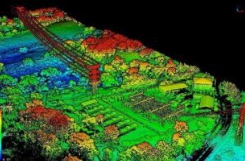
Drone-mounted LiDAR systems use a combination of GPS, inertial measurement units (IMUs), and high-frequency laser scanners to capture millions of data points per second. The result is a detailed “point cloud” that can be processed into 3D models, topographic maps, and more—critical assets in the land development workflow.
Enhancing Site Planning and Design
Before any development can begin, thorough site analysis is essential. Drone LiDAR allows developers to quickly gather comprehensive terrain data, enabling accurate assessment of slopes, water flow, and elevation. These insights are vital when designing infrastructure such as roads, drainage systems, and foundations. Moreover, it helps in identifying potential obstacles and natural features that need to be preserved or altered, reducing the risk of costly errors during construction.
By integrating LiDAR data into CAD and GIS platforms, architects and engineers can simulate design scenarios and make informed decisions early in the project lifecycle. This results in more efficient planning, minimized environmental impact, and better overall outcomes.
Streamlining Construction and Progress Monitoring
Land development is not a one-time survey operation—it’s an evolving process that requires ongoing monitoring. Drone LiDAR shines in this context by offering consistent and up-to-date data collection without interrupting site activities. Project managers can conduct regular aerial scans to compare as-built progress with design specifications, ensuring that timelines are met and quality standards upheld.
In addition, drone-collected LiDAR data enables volumetric analysis, which is particularly useful for measuring stockpiles, excavation depths, and material movement over time. These metrics are invaluable for budgeting, resource planning, and compliance documentation.
Facilitating Environmental and Regulatory Compliance
Environmental considerations play a significant role in modern land development. Accurate mapping is essential for identifying flood zones, protected habitats, and erosion-prone areas. Aerial LiDAR mapping provides the clarity and detail required to evaluate environmental risks and incorporate mitigation measures into planning.
Furthermore, regulatory bodies often require detailed terrain and impact reports before granting development permits. Drone-based LiDAR surveys meet these needs by delivering reliable and timely data that complies with governmental standards, thus expediting the approval process.
Overcoming Surveying Challenges in Difficult Terrain
One of the standout advantages of drone LiDAR is its ability to operate in areas where traditional ground surveying is impractical or unsafe. Whether it’s steep slopes, thick forests, or remote regions, drone-based systems can access and map these areas with ease. This not only improves safety but also drastically reduces the time and labor associated with conventional methods.
In regions prone to unpredictable weather or seasonal accessibility issues, rapid deployment of drones ensures that surveys can be completed during narrow operational windows—keeping projects on track and within budget.
Conclusion: Precision Delivered from Above
As land development becomes increasingly complex, the tools used to plan and execute it must evolve. Drone LiDAR technology represents a leap forward in terms of speed, precision, and versatility. From early site analysis to construction monitoring and regulatory compliance, its applications are as varied as they are impactful.
For developers and project managers seeking dependable, state-of-the-art aerial data solutions, High Exposure offers expert services tailored to meet the unique needs of each project. With a commitment to accuracy and innovation, they empower clients to navigate every stage of land development with confidence.

